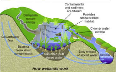
Identifying Wetlands and Their Functions
Floodplains are one of the most important landforms in watersheds.
Identifying and mapping them can support many types of watershed management and restoration activities.
NetMap characterizes floodplains in a couple of different ways:
One is in terms of absolute elevation above channels.
Another is in terms of bankfull depths, a measure often used by geomorphologists. Two multiples of bankfull depth are often considered the active floodplain.
Many floodplains have been isolated from their channels by over a century of land use activities, particularly urbanization and agriculture.
NetMap’s floodplain tools can identify historically active floodplains, useful when considering restoration activities.
TerrainWorks floodplain maps can identify side channels, alluvial fans, oxbow lakes and their connections to main channels and marshes.
To identify topographic depressions, like existing or historical wetlands, NetMap calculates standard deviation from mean elevation. This is particularly useful for identifying off-channel environments that could be reconnected to rivers to restore fish habitats.
One can quickly identify roads in floodplain corridors for restoration. Or seek additional protection from floods and their increases in frequency by climate change.
The floodplain tool can estimate how much excavation within existing topographic depressions (but now abandoned) would be required to reconnect them to the active channel, relevant information for restoration.


